


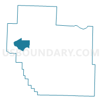
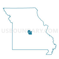
Bagnell Voting District, Miller County, Missouri
About
Outline

Summary
| Unique Area Identifier | 609104 |
| Name | Bagnell Voting District |
| County | Miller County |
| State | Missouri |
| Area (square miles) | 11.81 |
| Land Area (square miles) | 11.58 |
| Water Area (square miles) | 0.23 |
| % of Land Area | 98.05 |
| % of Water Area | 1.95 |
| Latitude of the Internal Point | 38.25725700 |
| Longtitude of the Internal Point | -92.59899280 |
Maps

Graphs
Select a template below for downloading or customizing gragh for Bagnell Voting District, Miller County, Missouri


Neighbors
Neighoring Voting District (by Name) Neighboring Voting District on the Map
- Aurora Springs Voting District, Miller County, MO
- Kaiser Voting District, Miller County, MO
- Lake Ozark Voting District, Miller County, MO
- Rocky Mount Voting District, Miller County, MO
- Tuscumbia Voting District, Miller County, MO
Top 10 Neighboring County Subdivision (by Population) Neighboring County Subdivision on the Map
- Glaze township, Miller County, MO (6,804)
- Franklin township, Miller County, MO (2,641)
- Equality township, Miller County, MO (1,109)